Training course on Geohazard Mitigation for Infrastructure Safety
Training Course on Geohazard Mitigation for Infrastructure Safety is meticulously designed to equip civil engineering, geotechnical engineering, geological, and infrastructure management professionals with the specialized knowledge and practical skills
Skills Covered
Course Overview
Training Course on Geohazard Mitigation for Infrastructure Safety
Introduction
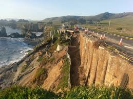
Infrastructure systems, vital for societal functioning and economic growth, are frequently exposed to a range of natural geological hazards, including landslides, earthquakes, sinkholes, soil liquefaction, and volcanic activity. These geohazards pose significant threats to the safety, stability, and operational continuity of critical infrastructure such as roads, bridges, railways, pipelines, and buildings. The increasing intensity of extreme weather events, coupled with rapid urbanization into hazard-prone areas, further exacerbates these risks, leading to catastrophic failures, loss of life, and immense economic disruption. Traditional engineering practices, while robust, often require specialized knowledge and proactive strategies to effectively identify, assess, and mitigate these complex geological risks. A comprehensive understanding of geohazard phenomena and the application of advanced mitigation techniques are therefore essential for ensuring the long-term safety and resilience of infrastructure assets. Training Course on Geohazard Mitigation for Infrastructure Safety is meticulously designed to equip civil engineering, geotechnical engineering, geological, and infrastructure management professionals with the specialized knowledge and practical skills required to assess geohazards and implement robust mitigation strategies for infrastructure safety.
Participants in this course will gain a deep understanding of the mechanisms behind various geohazards and learn to apply methodologies for conducting comprehensive geohazard assessments and risk analyses specific to infrastructure projects. The curriculum will delve into cutting-edge mitigation strategies, including ground improvement techniques, slope stabilization methods, seismic design principles, and advanced monitoring technologies. Through a blend of theoretical instruction, hands-on risk assessment exercises, and in-depth case studies of successful geohazard mitigation projects globally, attendees will develop the expertise to identify potential geohazards, formulate effective mitigation plans, evaluate the technical and economic viability of different solutions, and navigate the complex regulatory and financing landscapes associated with geohazard management. This course is indispensable for professionals committed to safeguarding infrastructure, protecting human lives, and building more resilient communities in geologically active or vulnerable regions. By mastering the principles and practices of geohazard mitigation, participants can lead efforts to minimize disaster impacts, enhance the safety and longevity of critical infrastructure, and contribute directly to global sustainability and disaster risk reduction goals.
Course Objectives
Upon completion of this course, participants will be able to:
- Understand the fundamental types and mechanisms of common geohazards affecting infrastructure.
- Apply methodologies for conducting geohazard identification, assessment, and risk analysis.
- Identify critical infrastructure vulnerabilities to various geological hazards.
- Develop and implement effective slope stabilization and landslide mitigation measures.
- Understand the principles of seismic design and earthquake-resistant infrastructure.
- Explore ground improvement techniques for mitigating soil liquefaction and settlement.
- Formulate strategies for managing risks associated with sinkholes and karst topography.
- Utilize advanced monitoring technologies for detecting and predicting geohazard movements.
- Integrate geohazard considerations into infrastructure planning, design, and construction.
- Navigate policy, regulatory, and institutional frameworks for geohazard management.
- Evaluate the economic benefits and costs of investing in geohazard mitigation.
- Analyze case studies of successful geohazard mitigation projects for infrastructure globally.
- Drive the implementation of proactive geohazard risk reduction strategies in infrastructure development.
Target Audience
This course is essential for professionals seeking to enhance infrastructure safety through geohazard mitigation:
- Civil Engineers: Specializing in infrastructure design, construction, and maintenance.
- Geotechnical Engineers: Focusing on soil mechanics, foundation design, and ground stability.
- Engineering Geologists: Identifying and assessing geological hazards.
- Infrastructure Managers: Responsible for the safety and resilience of existing assets.
- Urban Planners: Integrating geohazard risks into land-use planning.
- Disaster Risk Reduction Specialists: Working on natural hazard mitigation.
- Government Officials: From public works, transport, and geological survey agencies.
- Environmental Consultants: Assessing environmental risks related to geological instability.
Course Duration
5 Days
Course Modules
Module 1: Introduction to Geohazards and Infrastructure Vulnerability
- Define common geohazards: landslides, earthquakes, sinkholes, soil liquefaction, volcanic hazards.
- Understand the mechanisms and triggers of various geological phenomena.
- Discuss the direct and indirect impacts of geohazards on different infrastructure types.
- Explore the concept of infrastructure vulnerability and exposure to geological risks.
- Overview of global trends in geohazard frequency and intensity.
Module 2: Geohazard Assessment and Risk Analysis
- Learn methodologies for geohazard identification, mapping, and zonation.
- Apply techniques for geological and geotechnical site investigations.
- Understand quantitative and qualitative approaches to geohazard risk assessment.
- Discuss the use of remote sensing and GIS for spatial geohazard analysis.
- Formulate risk matrices and prioritize mitigation interventions based on assessment findings.
Module 3: Slope Stability and Landslide Mitigation
- Analyze factors contributing to slope instability and landslide mechanisms.
- Explore various slope stabilization techniques: retaining walls, soil nailing, rock bolting.
- Discuss drainage solutions for reducing pore water pressure in slopes.
- Understand the role of vegetation and bioengineering in slope protection.
- Design and implement monitoring systems for slope movements.
Module 4: Seismic Design and Earthquake Engineering
- Understand the principles of earthquake ground motion and seismic wave propagation.
- Learn about seismic design codes and standards for infrastructure.
- Explore earthquake-resistant design strategies: base isolation, energy dissipation, structural ductility.
- Discuss retrofitting and strengthening techniques for existing infrastructure against seismic forces.
- Analyze the performance of infrastructure during past earthquakes and lessons learned.
Module 5: Ground Improvement for Soil Liquefaction and Settlement
- Define soil liquefaction and its devastating effects on infrastructure.
- Explore ground improvement techniques to mitigate liquefaction (e.g., vibro-compaction, stone columns, deep mixing).
- Discuss methods for controlling excessive settlement and differential settlement.
- Understand the use of geosynthetics for soil reinforcement and stabilization.
- Apply ground improvement selection criteria for different soil conditions.
Module 6: Mitigation of Sinkholes and Karst Hazards
- Understand the formation mechanisms of sinkholes and their risks to infrastructure.
- Explore geological investigation methods for identifying karst features.
- Discuss mitigation strategies: grouting, foundation design, drainage control.
- Learn about risk management and monitoring for infrastructure in karst regions.
- Analyze case studies of sinkhole impacts and mitigation efforts.
Module 7: Advanced Monitoring and Early Warning Systems
- Explore various geotechnical instrumentation for monitoring ground deformation (e.g., inclinometers, extensometers).
- Discuss the use of GPS, LiDAR, and InSAR for remote sensing of ground movements.
- Understand the application of real-time monitoring and data analytics for early warning.
- Learn about drone technology for rapid post-geohazard assessment.
- Design a comprehensive monitoring plan for an infrastructure asset in a geohazard zone.
Module 8: Policy, Governance, and Planning for Geohazard DRR
- Review national and local policies on geohazard management and land-use planning.
- Discuss institutional coordination and multi-agency collaboration for geohazard risk reduction.
- Explore risk-informed spatial planning and development regulations in hazard-prone areas.
- Understand the role of public awareness and education in geohazard preparedness.
- Analyze challenges in policy implementation and enforcement for geohazard mitigation.
Training Methodology
- Interactive Workshops: Facilitated discussions, group exercises, and problem-solving activities.
- Case Studies: Real-world examples to illustrate successful community-based surveillance practices.
- Role-Playing and Simulations: Practice engaging communities in surveillance activities.
- Expert Presentations: Insights from experienced public health professionals and community leaders.
- Group Projects: Collaborative development of community surveillance plans.
- Action Planning: Development of personalized action plans for implementing community-based surveillance.
- Digital Tools and Resources: Utilization of online platforms for collaboration and learning.
- Peer-to-Peer Learning: Sharing experiences and insights on community engagement.
- Post-Training Support: Access to online forums, mentorship, and continued learning resources.
Register as a group from 3 participants for a Discount
Send us an email: info@datastatresearch.org or call +254724527104
Certification
Upon successful completion of this training, participants will be issued with a globally recognized certificate.
Tailor-Made Course
We also offer tailor-made courses based on your needs.
Key Notes
- Participants must be conversant in English.
- Upon completion of training, participants will receive an Authorized Training Certificate.
- The course duration is flexible and can be modified to fit any number of days.
- Course fee includes facilitation, training materials, 2 coffee breaks, buffet lunch, and a Certificate upon successful completion.
- One-year post-training support, consultation, and coaching provided after the course.
- Payment should be made at least a week before the training commencement to DATASTAT CONSULTANCY LTD account, as indicated in the invoice, to enable better preparation.